Post-eruption seafloor mapping following the VEI 5-6 eruption Hunga Tonga-Hunga Ha’apai volcano, Tonga, January 2022

Post-eruption seafloor mapping following the VEI 5-6 eruption Hunga Tonga-Hunga Ha’apai volcano, Tonga, January 2022Kevin MackayNational Institute of Water and Atmospheric Research (NIWA), New Zealand
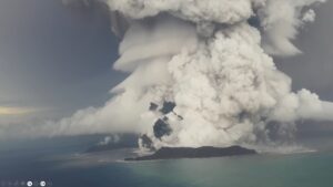
Hunga Tonga – Hunga Ha’apai (HTHH), one of 22 volcanoes in the waters around the Kingdom of Tonga, erupted violently on 15th January 2022. This eruption triggered shock waves through the atmosphere and generated a tsunami across the Pacific Ocean. No part of the caldera of the volcano remains above water following the eruption, and the islands of Hunga Tonga and Hunga Ha’apai were vastly reduced in size. During an oceanographic surveys 3-6 months after the eruption, we assessed the impacts of this eruption on the surrounding ocean environment, from underwater topography to ecosystem structure and function. While the HTHH edifice was largely intact, erosional channels were identified radiating out from the summit caldera indicating turbulent pyroclastic density flows which are supported with our modelling. At least 6 km3 of material was deposited on the seafloor in areas downstream of these pyroclastic flows, and >50cm of fine ash deposition was observed on the seafloor in some areas. Mid-water volcanic ash layers north of the HTHH caldera were identified which indicate on-going venting from the volcano. Significant seafloor ecosystem impacts were found throughout much of the region, with little signs of life remaining on the flank of the volcano and along the deeper slope. However, diverse and abundant invertebrate and fish communities were seen on the summits of several of the adjacent seamounts. This study is a rare account of the initial impact of a large-scale eruption which can be used to better understand volcanic risks to the ocean environment in the future.